Liverpool City Council
Tree preservation zone
There is a problem
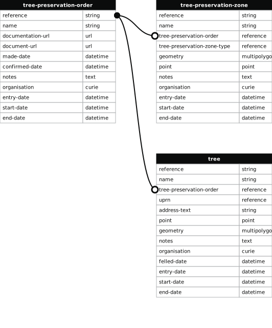
- tree-preservation-order column must match the reference field in the tree preservation order dataset
Land between Hornby Road, Stuart Road and Rawcliffe Road L4 & L9
- reference
- TPO410.W1
- name
- Land between Hornby Road, Stuart Road and Rawcliffe Road L4 & L9
- tree-preservation-order
- TPO410
- tree-preservation-zone-type
- woodland
- geometry
- MULTIPOLYGON (((-2.971318 53.451038,-2.971288 53.451039,-2.971268 53.451030,-2.971054 53.451247,-2.970841 53.451442,-2.970852 53.451455,-2.970778 53.451519,-2.970721 53.451572,-2.970592 53.451686,-2.970306 53.451945,-2.970145 53.452089,-2.970061 53.452162,-2.969992 53.452226,-2.969871 53.452331,-2.969647 53.452544,-2.969496 53.452691,-2.969421 53.452770,-2.969199 53.452980,-2.968803 53.453359,-2.967773 53.454348,-2.968086 53.454461,-2.968032 53.454526,-2.968109 53.454549,-2.968066 53.454600,-2.968107 53.454612,-2.968080 53.454643,-2.968040 53.454631,-2.968029 53.454643,-2.968121 53.454669,-2.968245 53.454701,-2.968420 53.454754,-2.968415 53.454758,-2.968407 53.454770,-2.968407 53.454773,-2.968395 53.454797,-2.968398 53.454798,-2.968286 53.454939,-2.968232 53.454988,-2.968184 53.454982,-2.968180 53.454977,-2.968170 53.454971,-2.968149 53.454963,-2.968099 53.454948,-2.968065 53.454984,-2.968062 53.454989,-2.968122 53.455008,-2.968019 53.455121,-2.968011 53.455135,-2.968089 53.455155,-2.967977 53.455332,-2.967974 53.455334,-2.967890 53.455475,-2.967745 53.455699,-2.967466 53.455639,-2.967287 53.455915,-2.967199 53.455908,-2.967145 53.456011,-2.967130 53.456045,-2.967083 53.456155,-2.966966 53.456455,-2.966836 53.456771,-2.966799 53.456858,-2.966690 53.457090,-2.966690 53.457101,-2.966692 53.457106,-2.966699 53.457116,-2.966706 53.457122,-2.967886 53.456886,-2.969535 53.456547,-2.969490 53.456466,-2.969572 53.456450,-2.969515 53.456328,-2.969625 53.456311,-2.969681 53.456428,-2.969715 53.456421,-2.969761 53.456501,-2.970234 53.456404,-2.970122 53.456207,-2.970045 53.456066,-2.969888 53.455788,-2.969689 53.455439,-2.969522 53.455140,-2.970694 53.454922,-2.970828 53.454922,-2.970862 53.454917,-2.970931 53.454912,-2.971012 53.454913,-2.971037 53.454917,-2.971048 53.454921,-2.971065 53.454931,-2.971072 53.454938,-2.971083 53.454954,-2.971089 53.454971,-2.971088 53.454988,-2.971074 53.455010,-2.971046 53.455036,-2.971022 53.455055,-2.971003 53.455067,-2.970982 53.455077,-2.970964 53.455089,-2.970957 53.455095,-2.970949 53.455108,-2.970950 53.455121,-2.970956 53.455134,-2.970966 53.455148,-2.970978 53.455161,-2.971025 53.455196,-2.971060 53.455219,-2.971098 53.455241,-2.971171 53.455279,-2.971246 53.455315,-2.971423 53.455396,-2.971644 53.455357,-2.971605 53.453780,-2.971589 53.453030,-2.971575 53.452530,-2.971571 53.452329,-2.971575 53.452317,-2.971577 53.452303,-2.971573 53.452279,-2.971580 53.452265,-2.971597 53.452239,-2.971679 53.452102,-2.971800 53.451906,-2.971877 53.451776,-2.972017 53.451550,-2.972057 53.451481,-2.972191 53.451266,-2.972495 53.450771,-2.972676 53.450481,-2.972766 53.450327,-2.972817 53.450247,-2.972874 53.450151,-2.972920 53.450079,-2.972948 53.450030,-2.973013 53.449924,-2.972553 53.449761,-2.972151 53.450153,-2.971642 53.450655,-2.971649 53.450655,-2.971607 53.450699,-2.971604 53.450708,-2.971597 53.450718,-2.971439 53.450874,-2.971327 53.450979,-2.971319 53.450992,-2.971315 53.451007,-2.971318 53.451038)))
- point
- POINT (-2.9699 53.454014)
- notes
- Mixed evergreen and deciduous tree species.
- entry-date
- 2012-10-12
- start-date
- 2013-04-12
- end-date
How to fix this issue
Your data is missing a tree-preservation-order.
The tree preservation zone guidance explains how to fix the issue:
tree-preservation-order
The reference for the tree preservation order that covers this zone.
How to improve Liverpool City Council’s data
- Fix the errors indicated
- Use the check service to make sure the data meets the standard
- Publish the updated data on the endpoint URL